 |
| Hemlock Wooly Adelgid on underside of hemlock needles. |
This new study plans to use existing data to develop a technique to prioritize hemlock forests that are most at-risk and have the highest conservation value. These results will provide landowners and managers with the tools necessary to identify where to deploy limited dollars and resources. The tool will help identify priority areas for monitoring and treatment.
 |
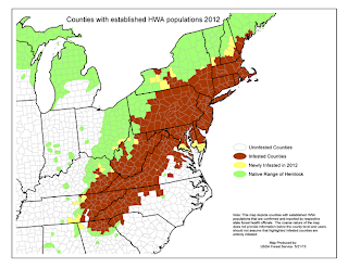
| Distribution of HWA and range of eastern hemlock. |
At this time, an interactive, web-based GIS tool has been developed. The tool allows maps of infestation risk and conservation priorities to be dynamic, adaptable, and up to date. To go to the web maps home page click here. To view the map, click the OPEN button below the map icon, and select the option to 'Open in ArcGIS.com map viewer' (first option). You can click on an area to get a pop-up window to display. The windows have a lot of information on the attributes of each of the priority areas, including the acres of hemlock (including areas where hemlock is very sparse) in each and the average basal area of hemlock.
In the future, this web site will be a component of a website that will include other information about the initiative including collaboration, hemlock conservation, HWA, control measures, outreach, etc. Development of that website will occur over the next several months, in conjunction with the formation of a Cooperative Forest Pest Management Area for the High Allegheny Plateau. Further refinements to these areas, and the inclusion of further data, will continue to occur as new information is provided.
To view and article that appeared in the Society of American Foresters, The Forestry Source, November 2013, Vol. 18, No. 11 click here.
Special thanks to Sarah Johnson, Conservation GIS Analyst, The Nature Conservancy, for heading up this project and providing much of this material.
No comments:
Post a Comment